Best Illawarra Escarpment Bushwalks. Where to Hike in Wollongong Nature
Want to hike, walk and explore the stunning Illawarra escarpment? Let us recommend our best Wollongong walking tracks. The stunning and rugged escarpment on NSW’s South Coast, is renowned for its biodiversity, indigenous significance and of course its views and walks. The heavy canopy of rainforest hides many special walking tracks, all of which are well worth an exploration! Here at What’s On In Wollongong, we have walked the best trails through our incredible ancient landscape. Pack your study shoes (and your leech salt), this one’s going to get a bit wild!
If you want to walk and have a refreshing swim in Wollongong, read our Best Illawarra Walks with Swimming Holes and Waterfalls. You may will also love The Sea Cliff Bridge. A local’s guide to Driving it, Walking it, Parking and What to do Near it + all the info about our Best Things To Do in Wollongong here
Mount Keira Ring Track
- 5.5km loop
- 3 – 4 hours with breaks
- Trailhead entrance: from Byarong carpark off Mount Keira Road
- Difficulty: Moderate (steps, hills, obstacles)
- No dogs or mountain bikes allowed
- Not easily accessible by public transport
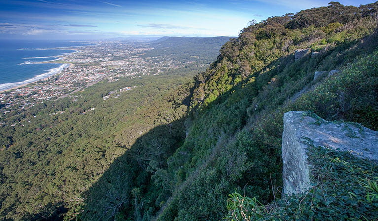
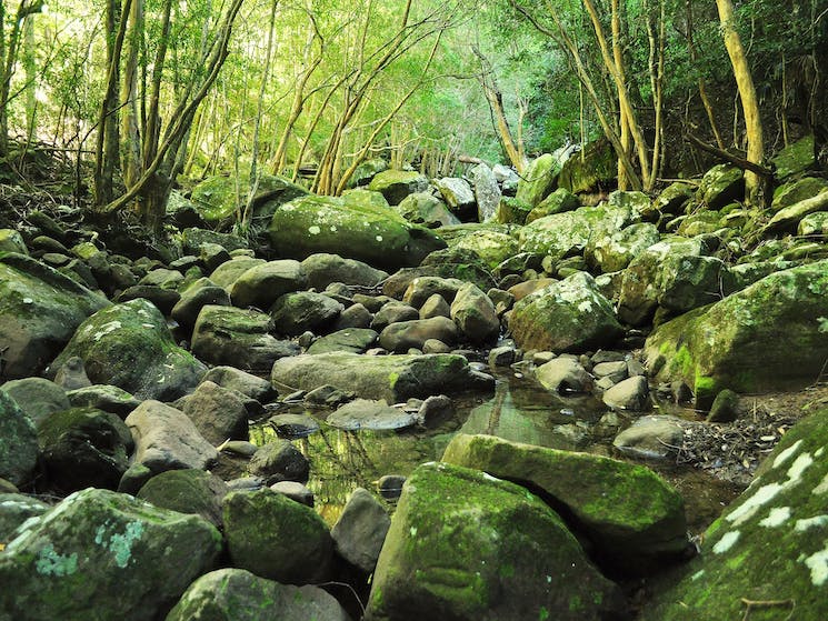
The Mount Keira Ring Track is a mildy challenging loop that winds around the face of Mount Kiera just below its summit.
You’ll get through some pretty unique landscape along this trail, from red cedar woodlands to dense coastal rainforest. In the spring, native wildflowers bloom all around and it’s a real treat. In the summer, the canopy and mountain breezes keeps things nice and cool. I’ve seen echidnas up here more than once, and wallabies too. Listen out for catbirds too — they sound bizarrely like cats crying (or monkeys? or babies?) Whip birds can be heard too — (they sound like a whip!)
And deer, of course. All over the escarpment we’ve got deer. And leeches. Bring your salt.
This track has lots of steps going up and down keep things interesting! And there are places where you have to cross over the road.
The trailhead starts from the Byarong car park at Mount Kiera Summit. Follow the signs from Byarong car park to the Girl Guide Camp entrance road. Cross that road, and continue on the trail to the signpost for the Ring Track.
You can either choose to do this trail clock-wise or anti-clockwise. Clockwise takes you up the mountain on the west side and down on the east: it’s the ‘downhill’ option. Anti-clockwise might be easier for those with bad knees for whom downhill is more trouble than uphill!
The track can be narrow in places, with steep drop offs and muddy sections. But it’s a lot of fun and really doesn’t have too much scrambling involved! You might want to consider a map, as sometimes finding the trail after crossing the road can be a bit tricky — everything is a bit overgrown! Note, it can become annoyingly muddy and hard to traverse in wet weather.
The 180 degree view from the summit is so, so beautiful, and Byarong Park picnic area has BBQ facilities and toilets and a relaxing vibe.
Mount Kiera Lookout is not easily accessible by public transport. The S108 bus runs from Wollongong as far as Mount Pleasant. It’s a 30min walk from there to the lookout.
Kelly’s Falls Track
- 500m one-way
- 30 mins, or as long as you like!
- Trailhead entrance off Kelly’s Falls carpark, Lawrence Hargrave Drive, Stanwell Tops.
- Difficulty: Easy
- Dogs not allowed
- Accessible by public transport
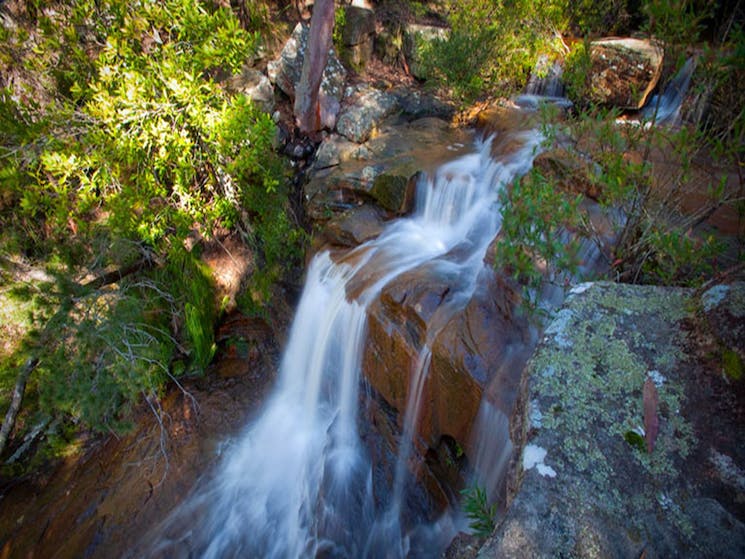
There are actually a few different walks around the very special Kelly’s Falls at Stanwell Tops. This post covers the short track that takes you around the clifftop.
The walk is an easy stroll around the top of the falls, taking in the incredible valley of gumtrees spread below and the rushing water over the falls from different vantage points as you circle around the cliff.
Park at the Kelly’s Fall’s Picnic Area, just off Lawrence Hargrave Drive at Stanwell Tops. The little road that leads to the carpark used to be hilariously pot-holed, but has recently been fixed up. There are two picnic tables and some signage here. At the end of the carpark the track on the left leads you down a few stairs to the top of the falls. Hop over the rocks to get to the lookout.
Note of caution: Beware of slippery rocks — near the water these rocks look normal but can be very slippery! I have landed on my bum more than once!
Following this trail around to the north-east will take you about 500m along the cliff top to a tiny creek crossing my children call ‘pixie falls’. The main track kind of ends here, but many little ‘wallaby trails’ lead off in every direction, and very fun to explore with kids. Mine always say they can see fairies twinkling in the moss.
Sometimes you’ll be surprised by horses and riders at the top of the falls. Mostly, you’ll find Eastern water dragons, nectar-drinking birds and snakes. And lots of flowers in the springtime. And leeches.
To the right, at the end of the carpark is the trailhead of The Princess Marina Track: a wild scramble from Kelly’s Falls all the way down to Stanwell Park. Traversing overgrown bush, mud, fire-trails and road crossings — this track is good fun, but poorly marked and maintained. Some source of navigation is recommended.
Note: There is a way down to the bottom of the falls if you turn left and head downhill about 100m along the Princess Marina Track. For safety reasons I don’t recommend it, because it requires abseiling/scrambling down sections of the cliff. It’s slippery and the unofficial guide ropes are often broken. But in high summer there is no water as cold at the bottom of the falls, so explore at your own risk!
Getting here by public transport is not the easiest, but still doable by train and then bus. The Illawarra Premier Bus Service runs a service from Helensburgh Railway Station to Stanwell Park (Route 15) that can stop at Kelly’s Falls.
Mount Kembla Ring Track
- 5.3km loop
- 2 – 3 hours
- Trailhead entrance: From the Mount Kembla Lookout carpark (off Cordeaux Road)
- Difficulty: Moderate
- No dogs allowed
- Difficult to access via public transport
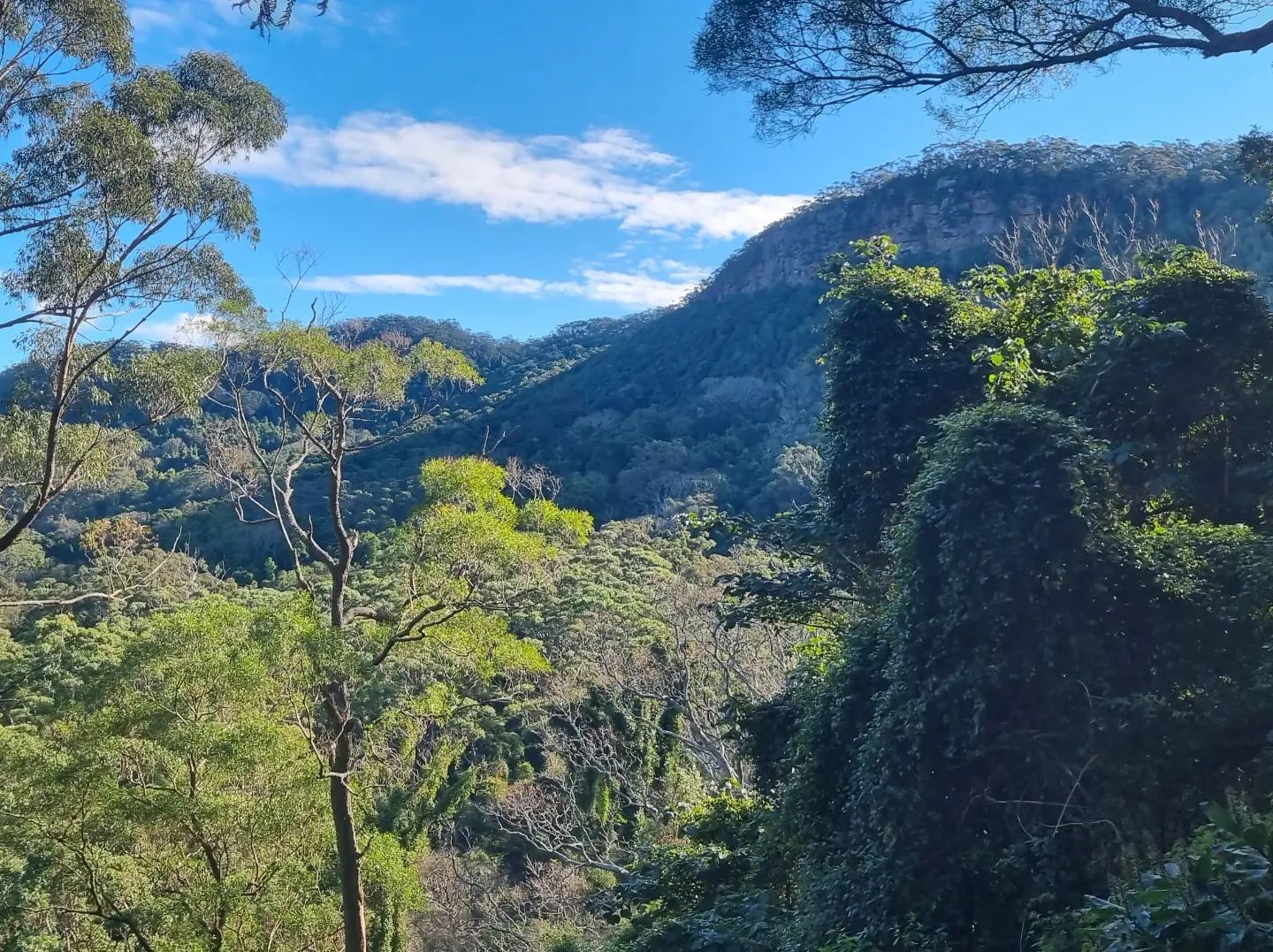
The peaceful Mount Kembla was originally named ‘Hat Hill’ by Captain Cook for its resemblance to a bowler hat. It is in fact an important site for the Wodi Wodi people, and central to the creation stories of this Country.
The Mount Kembla Ring Track takes a half-bush, half-road loop around Mount Kembla, and gives you the option to access the Kembla Lookout via the Summit track.
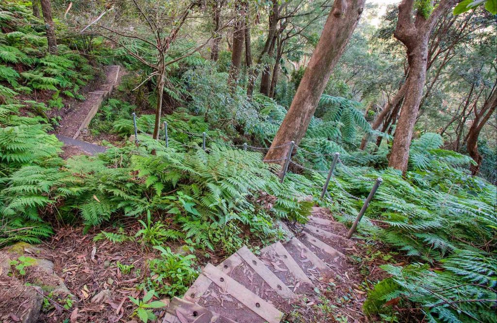
There are not many ocean views to be had along the way, but there are plenty of beautiful bird calls, and some old coal mining infrastructure to check out. The first kilometre of track passes through the rainforest, and has about 100 steep steps down to the valley floor. After that the track becomes a fire trail as it wraps the mountain. The final 1.5 kilometres is along the road, which some people dislike, but I find to be easy going and enjoyable. Lots of people actually prefer to do this walk in reverse from the Windy Gully end, saving the rainforest for last — but then you have to go upstairs!
While well marked, the track is not always well maintained, with mud and fallen leaves making for slippery footing. And I have to add the obligatory leech warning. Holy-moly there’s a lot of leeches up here.
The trailhead entrance is off the carpark at Mount Kembla lookout, just off Cordeaux Road. Head over the clearing next to the carpark to reach the entrance. To your right are the signs to follow for Mount Kembla Ring track.
There is a bus service (Route 35) departing from Wollongong Station that will eventually get you to Kembla Heights, but it’s a real slog so not really recommended.
The Wodi Wodi Track
- 6kms long one way
- 3-4 hours with breaks
- Trailhead entrance: Stanwell Park Railway Station or Lawrence Hargrave Drive, Coalcliff.
- Difficulty: Hard
- Dogs not allowed
- Accessible by public transport
The famous Wodi Wodi Track is named for the Wodi Wodi people, who are the traditional custodians of this part of Dharawal Country.
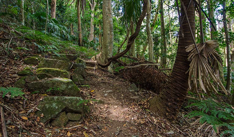
The track takes you through the wild bushland between Stanwell Park and Coalcliff. The biodiversity on this walk is astounding. Along the way you’ll cross creeks, giant boulders, pass under sandstone caves and get to see the most stunning views of Stanwell Park Beach. Colossal gymea lilies bloom in the spring and gum trees reach to the skies. There is a whole forest of cabbage tree palms in the sub-tropical tangle of ferns. Both black and white Cockatoos frequent the gums, and friends say they’ve seen falcons too! Diamond pythons and Eastern water dragons like to sun themselves on the rocks near the creeks. Yabbies (or in local lingo, ‘Crawchies’) can be seen in the water too.
The track itself is rough going. Not very well marked, lots of scrambling over rocks, very steep and narrow in places! There is a lot of clay in the soil and it can be slippery in rainy weather.
This track can be started from either end. I recommend starting at Stanwell Park Railway Station and walking to Coalcliff. There is a small carpark opposite the Coalcliff entrance on Lawrence Hargrave Drive.
Some walkers prefer to return to Stanwell Park on the footpath along Lawrence Hargrave Drive instead of the trail. (I often see dolphins off the cliffs walking this section of footpath!)
There is clear signage at each end, and at the two junctions along the track. Taking a detour via the Forest Path will take you to the summit of Mount Mitchell. But, finding the track again can sometimes be a pain. Having a map or a navigation app with you is a good idea – folks do get lost up here!
Note about critters: Keep an eye out for leeches in the wetter months and ticks in the summer. There are lots of both. Also make a bit of noise walking the sunnier sections of track, Red-belly black snakes are very shy and will not stick around if they hear you coming.
This track is accessible by public transport. The Stanwell Park trailhead is right next to the Railway Station. The other Coalcliff trailhead is only about 500m from Coalcliff Railway Station. You might like to use the train to make this a ‘point-to-point’ walk.
Sublime Point Track
- 800m one-way
- Between 30 minutes and 2 hours depending on your fitness!
- Start at either end: Bottom entrance Foothills rd. Top entrance Sublime Point Lookout.
- Difficulty: Hard!
- Dogs not allowed
- Accessible by public transport
Great news! The Sublime Point Track is now open! The Sublime Point Track is an iconic near-vertical trail in the foothills of Austinmer. It’s become very popular in recent years with folks looking for a challenging work out — and that’s exactly what it delivers.
The track covers 800 metres of steep uphill climbing. There are over 1000 wooden/dirt stairs and a series of metal ladders to climb to get to the top. The trail is narrow in places, so when it gets busy you’ll find yourself squeezing to one side to let folks past. I’ve been overtaken by super fit people who actually run this track! Thank goodness the National Park put in some benches for the rest of us. If the climb doesn’t take your breath away, the view from the top will.
The scenery is beautiful, coastal bush and magic woodland. The tree ferns, bracken and cabbage tree palms create a dense fairy-land all around, with glimpses of bright blue sea as you climb higher and higher. Sweet black cockatoos are always around, and once we saw a leaf tailed gecko on a bench!
You can start the track at the top or the bottom, I prefer to start at the bottom, so my home-ward journey is downhill!
Once at you’ve reached the summit, there is a lovely grassy picnic area to explore. North of the trail you’ll find The Sublime Point Cafe, the lookout, toilets, BBQ’s and picnic shelters.
The trailhead at the bottom is off Foothills Road in Austinmer. This is a residential street, but there is always plenty of parking. The entrance at the top is to the right of Sublime Point Lookout. There is clear signage at both ends.
Before it was closed, the track was one of the best maintained in the area, well sign-posted and easy to follow. That being said, it becomes very difficult to climb in rainy weather. Slippery with clay-mud and absolutely abundant with leeches! Seriously, this little piece of paradise seems to be home to more leeches and ticks than anywhere else on the list. Bring salt! Check for ticks!
The Sublime Point Walking track is accessible by train from Austinmer station. Though this option adds more hills to your walk – ‘cause let me tell you – it’s all uphill from the station to Foothills Road.
There are a few options to extend or shorten the walk. This track intersects with the Gibson Trail which runs along the foothills. It also meets the Woodward Trail at the top, which runs along the escarpment.
Note: this track is suitable for experienced hikers due to its challenging nature. But if you’re happy to take it slow, the rewards are worth it!
Looking for an easy-going escarpment walk?
Why not check out beautiful Broker’s Nose near Bulli…
Or keep exploring with these family friendly walks…
Gelato Emporium, Bulli Tops

Heading out for an escarpment bushwalk? The Gelato Emporium at Bulli Tops (located within the Southern Gateway Centre), makes the perfect pit stop before or after your adventure. Refuel with quality coffee, artisan gelato or a gourmet sandwich while soaking up sweeping coastal views. It’s an easy, scenic place to recharge, cool down and treat yourself after hitting the trails. Plan your visit to the Gelato Emporium here.
Altitude 1148 – High Tea

After an Illawarra escarpment bushwalk, there’s no better reward than heading to Altitude 1148 for a well-earned high tea. Think sweet treats, savoury bites and endless tea (or something bubbly) while soaking in those incredible coastal views you’ve just explored. The perfect way to refuel, relax and take it all in. Book now/learn more.
We offer our gratitude and deep respect to the lands, waters and skies of Dharawal Country. We stand in solidarity with its traditional custodians, the Dharawal and Wodi Wodi people, whose sovereignty was never ceded.
After more events and businesses near you? Never suffer FOMO again with our Weekly Newsletter sent straight to your in-box! Sign up HERE
You might also like:
- Best Things to do in Thirroul: Insider’s Guide
- The Sea Cliff Bridge. A local’s guide to Driving it, Walking it, Parking and What to do Near it
- 5 Best Walks in Wollongong and the Illawarra your Family will Love
- Best Things to do in Wollongong: Best Attractions, Best Eats, Best Pubs, Best Night Life
- Dining Guide to Thirroul – where to eat, where to drink
- 10+ Best Craft Breweries in Wollongong & Illawarra
- Your Local Guide to 20 Awesome Markets Across the Wollongong, Shellharbour and Illawarra
- Beachside Dining in Wollongong – Local Cafes and Restaurants
- Need more Wollongong eat and drink inspo? Click here
- 8 of the best lesser known things to do in and around Wollongong
- Live Music Wollongong Guide. Find Live Music Venues, Bands and Gigs Near Me
- Your Guide to Lunch and Dinner Specials From Local Restaurants in and Around Wollongong